Miscellaneous Trail Facts

“There are currently over1,212 trails for 12,585 miles of greenway trail in the U.S.”

Rails to Trails Conservancy, Trail facts

“A greenbelt (trail) in Boulder, Colorado increased aggregate property values for one neighborhood by $5.4 million, resulting in $500,000 of additional annual property tax revenues. The tax alone could recover the initial cost of the $1-5 million greenbelt in three years.”

Economic Impacts of Protecting Rivers, Trails, and Greenway Corridors – National Park Service, 1990.

“Trail users spend money. Such expenditures may range from snacks or drinks to bicycle repair or purchase to overnight stays. Communities that serve as trailheads are poised to take advantage of this economic inflow. A study for the National Park Service undertaken in 1992 estimated that trail users spend between $4 and $11 per day, depending on trail location and spending opportunities. This can equate to between $1.2 and $1.8 million for one trail for one year.”

Iowa Trails 2000, Iowa Department of Transportation

“According to the U.S. Department of Health and Human Services, “approximately 300,000 U.S. deaths a year are associated with obesity and overweight (compared with 400,000 deaths a year associated with cigarette smoking). The total direct and indirect costs attributed to overweight and obesity amounted to $117 billion in the year 2000.” The alarming national statistics point to a growing health crisis that impacts Americans of all ages. The Surgeon General recommends moderate physical activity — 30 minutes a day, five days a week — to combat the threat of diseases including high blood pressure, coronary heart disease, Type 2 diabetes, certain forms of cancer and depression.”

Rails to Trails Conservancy, health benefits of trails

Another Story linking Health, Lifestyle, and Bad Urban Planning

The way cities and suburbs are developed could be bad for your health
By Martha T. Moore
USA TODAY Page 1A

Why don’t Americans walk anywhere?
Old answer: They’re lazy.
New answer: They can’t.

There is no sidewalk outside the front door, school is 5 miles away, and there’s a six-lane highway between home and the supermarket.

Many experts on public health say the way neighborhoods are built is to blame for Americans’ physical inactivity — and the resulting epidemic of obesity.

The health concern is a new slant on the issue of suburban sprawl, which metro regions have been struggling with for a decade. These health experts bring the deep-pocketed force of private foundations and public agencies into discussions about what neighborhoods should look like.

The argument over whether suburbs are bad for your health will hit many
Americans precisely where they live: in a house with a big lawn on a cul-de-sac.

”The potential for actually tackling some of these things, with the savvy of the folks who have tackled tobacco, is enormous,” says Ellen Vanderslice, head of America Walks, a pedestrian advocacy group based in Portland, Ore.

A study by the federal Centers for Disease Control and Prevention is tracking 8,000 residents of Atlanta to determine whether the neighborhood they live in influences their level of physical exercise.
The Robert Wood Johnson Foundation in New Jersey, the country’s largest health care philanthropy, is spending $70 million over five years on studies and programs to make it easier for people to walk in suburbs, cities and towns. ”We want to engineer routine activity back into people’s daily lives,” says Kate Kraft, the foundation’s senior program officer. ”That means we need to start creating more walkable, bikeable communities.”

For decades, cities, towns and suburbs have been developed on the assumption that every trip will be made by car. That has all but eliminated walking from daily life for people in most parts of the country. Americans make fewer than 6% of their daily trips on foot, according to studies by the Federal Highway Administration.

Three-quarters of short trips, a mile or less, are made by car, federal studies show.

Children don’t get much more of a workout. Fewer than 13% of students walk to school. That’s partly because regulations for school construction effectively encourage building schools on large sites at the edge of communities, beyond walking distance for most students, according to a National Trust for Historic Preservation report.

Federal health statistics show that nearly 65% of Americans are overweight and that 31% are obese, or more than 30 pounds over a healthy weight. A big part of the cause is all that driving and not enough walking.

”Obesity is not just (that) we’re eating more. We’re getting less activity. People just don’t walk that much,” says Tom Schmid, head of the CDC’s Active Community Environments program.

Why you can’t walk there from here:

* Spread-out neighborhoods. Bigger houses on bigger lots mean neighborhoods stretch beyond walking distance for doing errands.

* Zoning. Residential neighborhoods are far from jobs and shopping centers, even schools.

* Reign of cars. Roads are built big and busy. Intersections and crosswalks are rare. Shopping centers and office parks are set in the middle of big parking lots, all of which have become dangerous places to walk. In many cul-de-sac suburbs and along shopping strips, sidewalks don’t exist.

Suddenly, the crowded city looks healthy.

In old, densely built cities such as New York and Boston, people walk.
It’s not necessarily for exercise, but simply to get from one place to another. College towns and cities with military bases also have high rates of walking, Census data show. Houses and workplaces are near each other. If people don’t walk to work, they often walk to public transit.

In November, Oakland became one of a few large cities to pass a pedestrian master plan. The city already has a walking-friendly design because it was laid out at the turn of the 20th century along streetcar lines. Nevertheless, city officials want to make sure that people can walk to a new rapid-transit bus system. That will mean spending money to upgrade sidewalks and intersections near the transit stops.

”It’s back to the future. We’re going to have this transportation system where you don’t need to drive,” says Tom Van Demark, director of
Oakland’s pedestrian safety project.

In newer cities, especially those in the Sun Belt where growth has boomed since 1950, walking anywhere is not easy. Families wanted more space for their children, so they moved to single-family houses with yards in big residential neighborhoods. Jobs and services, like shopping, followed people to the suburbs, away from the downtown that could easily be served by public transit.

Hopping into SUVs

Even in places designed to be walkable, things have changed. Victoria
Talkington, a lawyer and mother of two children, lives north of San Francisco in Mill Valley, on the slopes of Mount Tamalpais. A network of paths and steps connects roads that switch back along the mountainside.
The footpaths lead from downtown into elevated residential neighborhoods.

But in the hundred years since the paths were laid out, they had fallen into disuse. Instead, people drive down the roads.

”People with SUVs and kids have moved in, and they’ve displaced people who knew about the paths,” says Talkington, a planning commission member.

Near her house is a path with a great view of the mountain. ”Nobody who lived within a hundred yards of it knew about it,” she says. So she took a pruner and cleared the overgrown path last fall.

Now, people occasionally use it.

Steven Gayle, director of the transportation system in Binghamton,
N.Y., is running seminars on pedestrian improvements, paid for by the Robert Wood Johnson Foundation. ”What we really need to do is redesign our communities so that people walk as a matter of course, the way they used to do,” Gayle says. ”Hopping in your SUV to drive to the park to walk on the trail for 20 minutes and hopping in the car to drive home is not what we need to see.”

Public health advocates are well-funded allies for advocates of ”smart growth,” who criticize suburban sprawl and development. They have been arguing for a decade that communities should be walkable. Neighborhoods should be built with shorter blocks, smaller yards and streets that connect to each other rather than dead-end. Stores and offices should be close to or mixed with residential neighborhoods, they say.

The Urban Land Institute, a group for developers and planners, estimates that 5% to 15% of new development follows the principles of ”walkable” neighborhoods. Nearly 1.6 million homes were built in 2001.

”There’s a big awareness of the issue in the planning community, that
walkable places are nicer and sometimes are more economically viable,” says Reid Ewing, a Rutgers University professor and author of an upcoming study on sprawl and health. ”The question is, are they healthier? That’s really the new wrinkle.”

To find the answer, the CDC and the Robert Wood Johnson Foundation are funding studies such as the one in Atlanta. The public health experts want to find out what kind of neighborhood designs and amenities have a statistically significant link to increased walking.

Some metro areas are taking steps to make their cities pedestrian-friendly, either by upgrading neighborhoods with sidewalks and crosswalks or changing the rules for building developments.

Lots of people walk in Rochester, N.Y. And enough people commute by bicycle that city buses are equipped with bike racks. But ”the suburbs are built without sidewalks and without adequate shoulders on the roads,” says Bill Nojay, chairman of the regional transportation authority.

Last year, the region spent $5 million to upgrade walking and biking trails that connect the 19 towns in the county surrounding Rochester.

‘Shocked into it’

Fewer people walk to work in Atlanta and Charlotte than in any other large metro areas, according to Census data. But both cities are trying to make walking easier. They want to focus development around public transit and spend money on sidewalks.

In Atlanta, poor air quality from traffic congestion forced the issue.
The region could not spend federal transportation funds on new highways until it came up with a plan to improve air quality.

”The only projects we could build were the small projects geared toward the pedestrian,” says Tom Weyandt of the Atlanta Regional
Commission, the metro area’s planning agency. ”So in a sense, we were sort of shocked into it.”

The region is spending $175 million to build 385 miles of sidewalks by
2005.

That’s a small slice of the region’s 16,000 miles of roads and highways. But $350 million more over 10 years will go to transportation projects tied to the development of higher-density, mixed-use areas.
Those will be mostly pedestrian improvements, Weyandt says.

In Charlotte, fewer people walk to work than any other metro area of more than 1 million people. The city also made the top 10 ”fattest cities” list in the February issue of Men’s Fitness magazine.

But a master plan adopted by the city in 1998 calls for development to be clustered along light-rail and rapid-bus lines to encourage people to walk to public transit. The city now requires new subdivisions to have sidewalks and few cul-de-sacs. Also, the city is hiring a ”pedestrian coordinator” to work with developers.

Voters approved a $10 million bond issue in November to build sidewalks in places that never had them. Less than half of Charlotte’s 2,800 miles of streets have sidewalks on one or both sides.

Most of the motivation for these changes has been to cut down on traffic and pollution.

”The community health aspect of it is one that’s just emerging as a topic,” says Danny Pleasant, deputy director of transportation for Charlotte.

Public health vs. the good life

Many people, of course, get physical exercise regardless of where they live.

And for good or ill, a suburban house in a bedroom community is to many people the American dream. ”A large part of what some people call sprawl is what other people call affordable housing, jobs, highways that go somewhere and get you there,” says Daniel Fox, president of the
Milbank Memorial Fund, a health policy research foundation based in New York.

Builders of suburban neighborhoods and office parks often view a
walkable development as expensive to construct, hard to get past local planning agencies and difficult to finance, says Clayton Traylor of the
National Association of Home Builders.

Also, the main component of walkable neighborhoods is density, or the number of people per square mile — but density is what many homebuyers are trying to get away from.

”It’s just our own definition of what the good life includes, which is a couple of cars and a house on the cul-de-sac,” says Kraft of the Robert Wood Johnson Foundation. ”The good life means you can be a couch potato.”

That may mean Americans don’t want to walk regardless of what public health experts urge. ”Population health is what the population says it is,” Fox says.
”Why can’t Americans change their values? Why can’t everyone in Texas, instead of going to high school football games, spend their Friday nights exercising? Well, that’s the way it is, folks.”

Even so, those pushing for walkable developments hope that a public health approach will be more palatable than talking about smart growth and sprawl.
”Too many people just don’t care at all about design or sprawl,” says
Adrienne Schmitz of the Urban Land Institute, based in Washington, D.C.
”But when you start talking health, it’s a real hot button.”

Building a Walkable Community

The Walkable Communities, Inc. website (www.walkable.org) has a list of several qualities that walkable communities have. Why should we be concerned if our community is walkable? Because communities which foster walking are healthier, develop stronger social ties, reduce certain infrastructure costs, and offer a higher quality of living. Quality of living is one of the leading indicators for economic development as well.

Among the qualities of a walkable community which Town Branch Trail is helping to develop are:
* intact town centers
* developments with residential densities, mixed income, mixed use.
* public space
* universal design
* connections of streets and trails
* many people walking
* visionary and forward thinking

The vision for Town Branch Trail includes revitalizing older neighborhoods and commercial areas along the proposed trajectory of the trail, encouraging adaptive reuse of older buildings and a mix of development types including office, retail, live-work, residential and neighborhood support services. Residents of these areas could use the trail to commute into the center of downtown, and also have access to daily needs within easy walking distance. Discussions about activities and businesses which would surround a major trail head where the creek emerges from the ground near Rupp Arena have generated some exciting ideas that will contribute to a vibrant downtown.

The trail is designed to be accessible to people in wheelchairs and using walkers, as well as those who run and bike. Parents with children in strollers also benefit from such “universal” design. Details such as shade and benches will add to the comfort of all people using the trail.

Town Branch Trail will connect to other trails and bikeways, and to major roadways such as Broadway, Main and Vine Streets, Forbes Road, Alexandria Drive and the future Newtown Pike extension. The Newtown Pike extension’s bike lane will connect Town Branch Trail to the UK campus. The trail also links two major public green areas, McConnell Springs and Masterson Station Park. When Town Branch Trail is completed, Rupp Arena and Convention Center events will be more accessible without driving.

The location and linkages of Town Branch mean that it will be well used; creating a safe, pleasant and interesting facility. Workers from various downtown businesses will mingle with convention goers and tourists, as school kids ride bikes or elderly neighbors go for a gentle stroll. Use will occur during normal business hours, after work and on weekends, bringing energy to many areas near downtown and beyond.

Walkable Communities Inc., 320 S. Main St, High Springs, FL 32643 (386) 454-3304

What Impact do trails have on Neighbors and the Local Community?

A study was done on impacts of the Pinellas Trail in Pinellas County
(Tampa/St Pete), Florida. Some information on the study (from Whit Blanton
of Renaissance Planning Group, which conducted the study) is included below:

In 2000, the Pinellas County MPO commissioned Renaissance Planning Group of
Orlando to conduct a study of the community impacts associated with the
Pinellas Trail, a 34-mile converted railroad in the St.
Petersburg/Clearwater area of Florida. The MPO was planning extensions of
the trail and connections to it from other communities, and had encountered
opposition from homeowner groups and others about potentially negative
impacts on property values, noise and crime. The study was intended to
evaluate economic impacts in terms of residential property values, business
investment, and crime statistics, and included a household survey of
residents living within 1/4 mile of the trail. The trail was divided into
segments to better capture the effect of surrounding land use and crime
characteristics. A national literature review was also completed.

Major findings:
The literature review concluded that trails have a deterrent effect on
crime, a neutral or slightly positive effect on property values, and bring
new money into the local economy. This was borne out by the local analysis.

For all trail segments studied, the median home sale prices adjacent to the
trail are escalating faster than countywide. The rate of increase was
particularly high in certain areas. The results indicated that the trail
does not negatively impact property values and suggested that it may help
increase property values by roughly 2 percent to 3 percent annually over
inflation.

In St. Petersburg, it was determined that crime rates for “trail tracts” were not statistically
different from citywide crime tracts. Accordingly, the Pinellas Trail does
not contribute to crime rates. Peaks in crime rates seem to be related to
the character of the area rather than to the existence of the Pinellas
Trail. Generally, the 1993, 1995, and 1999 crime statistics support the
finding that the trail has not exacerbated criminal activities. Factors
external to the trail are better indicators of crime rates.

There were several important findings from the residents’ survey. The most
negative perceptions of the trail are held by the 5 percent of residents who
have never used the trail. Even though infrequent users gave the Pinellas
Trail a negative overall rating, their composite score was not as low as the
score given by residents who had not been on the trail. Infrequent users
were primarily concerned about the trail’s adverse impact on crime, privacy,
and noise. As a group, they still rated the trail as having a positive
impact on property values, accessibility, and neighborhood acquaintances.
Daily users had the highest composite rating of the trail; however, they
were still marginally concerned about crime (0.09) and privacy (0.05). The
single strongest indicator of trail perception is trail usage and, because
of the high use of the trail (66%), the overall perception of the trail is
positive.

While the trail is generally seen as a community asset, the neighborhoods
that are the most concerned about the Pinellas Trail are those who perceive
inequities between communities in the way that the trail is constructed,
maintained, and policed.

Realtors were surveyed as well, and 90 percent said that home sales had
increased significantly or increased somewhat in areas near the trail versus
other areas in the market.

The business survey revealed that a majority of businesses near the trail
were expanding their facilities or experiencing increasing sales, and
generally reported positive impacts from their proximity to the trail.

Copies of the report can be obtained by contacting Al Bartolotta of the
Pinellas County MPO (727-464-8200; abartolo@co.pinellas.fl.us
). RPG contact is Whit Blanton. (wblanton@citiesthatwork.com

Jennifer Z. Carver, AICP
Bicycle & Pedestrian Program Planner
Capital Region Transportation Planning Agency
300 South Adams Street
Tallahassee, FL 32301
(850) 891-8090 S/C 280-8090
Fax: (850) 891-8734
carverj@talgov.com

Landmarks along Town Branch

Masterson Station Park. Lexington’s largest park, once pastures for Kentucky’s first Methodist Church built in 1787. Rambling park offers equestrian facilities, a dog run, soccer fields, bird nesting areas and ample greenspace.

Town Branch Greenway Phase I and II of the trail have been planned, funded and await construction. This initial two mile segment runs from Bracktown and the entrance of Masterson Station to Lewis Manor and Alexandria Drive.

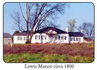
Lewis Manor. Federal-style national register home built at the turn of the 19th century by Col. Thomas Lewis, a Revolutionary War veteran. Home is adjacent to historic spring that feeds Town Branch.

Wolf Run Creek. As a tributary to Town Branch Creek, Wolf Run provides a potential link for a trail into the Cardinal Valley neighborhood.

Veterans’ Hospital. Handsomely landscaped campus of stately Colonial Revival medical buildings that have served the Bluegrass since 1931.

Former City landfill. This site is undergoing extensive environmental clean up. Like Raven’s Run, it has the potential to provide vital reclaimed greenspace.

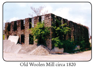
Old Woolen Mill. Built circa 1820, this large stone ruin is the oldest remaining industrial building along Town Branch. The mill later served as a jail and city work house. It is owned by the urban-county government.

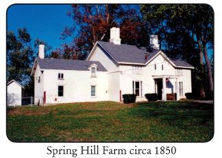
Spring Hill Farm. National register Greek Revival farmhouse and outbuildings circa 1850 encircled by a rock fence. It is owned by the urban-county government.

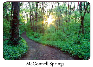
McConnell Springs. Site of the founding of Lexington in 1775. A recently dedicated city park with a engaging interpretive trail. The Blue Hole spring and lofty bur oaks afford a pleasant stroll through our unique karst topography.

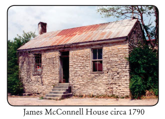
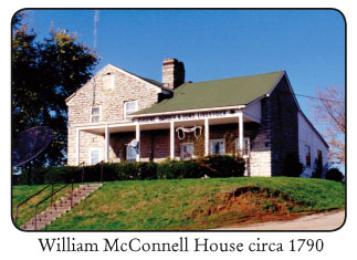
McConnell Houses. William and James McConnell, pioneer founders of Lexington, built two dry-laid stone houses circa 1790 along Town Branch Creek. These are among the oldest structures remaining in the Bluegrass.

James E. Pepper Distillery. Home to “Old 1776.” One of the earliest sites for bourbon making in the Bluegrass pulled water from a neighboring spring. Large buildings used in bourbon-making remain beside Town Branch Creek.

Town Branch Creek Stone Walls. Despite a century of neglect, dry-laid stone creek banks that date back to Lexington’s early history still line the stream.

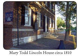
Mary Todd Lincoln House. The childhood home of one of Lexington’s most famous citizens is now a beautifully restored house museum with a formal garden.

Lexington Civic Center and Heritage Hall. A premiere state venue for conventions, athletics, and entertainment. In Triangle Park a 300-foot long cascading fountain is a favorite gathering place on summer evenings.

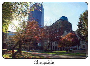
Old Courthouse and Cheapside Park. The Old Courthouse was built in 1899 on the site used for Fayette County Courthouses for 200 years. Cheapside Park has been the scene of a wide spectrum of community history from slave auctions, early schools and markets to political speeches and public riots.

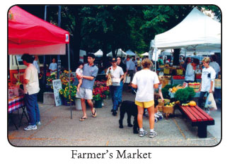
Farmer’s Market. On Saturday mornings during the growing season Lexingtonians can find the finest local and regional produce at this vibrant outdoor marketplace. Site of former 1879 Lexington City Market House.

New Courthouse Plaza and Phoenix Park. New public urban spaces stand in the midst of art galleries, theatres, restaurants, and a dramatic five story Foucault Pendulum and Clock in the central library.

Bank One Plaza and the Kentucky Theater. This Main Street park is a favorite outdoor spot for a picnic lunch from the various nearby restaurants. Across the street is Lexington’s historic

Kentucky Theater, a 1922 ornate movie house restored as a favorite venue for live performances and movies.

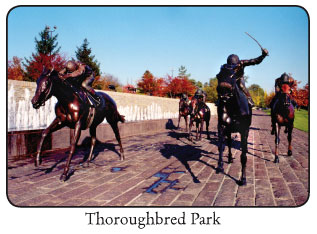
Thoroughbred Park. A linear fountain anchors elegant stone work and superbly rendered bronze sculptures of racing thoroughbreds. A rose garden awaits the winner.

Charles Young Park and Goodloetown. Here the Trail will link to another of Lexington’s historic African-American settlements and to one of the city’s older neighborhood parks, named after an African-American veteran of WWI.


How can Town Branch Trail benefit our community?Download TBT 4-page Guide (1.6 Megabyte PDF)